Tuesday 31 May 2011

Ramya Sree


Name:          RamyaSree
height:          5'6
weight:         58kg
colour:         white
looks:          very fair

Sunday 29 May 2011

Tower Bridge


London's Tower Bridge is one of the most recognizable bridges in the world. Its Victorian Gothic style stems from a law that forced the designers to create a structure that would be in harmony with the nearby Tower of London.


Bridge History
Plans for the Tower Bridge were devised around 1876 when the east of London became extremely crowded and a bridge across the Thames in that area of the city seemed a necessity. It would take another eight years - and lots of discussions about the design - before construction of the bridge started.


The bridge, designed by city architect Horace Jones in collaboration with John Wolfe Barry, would eventually be completed in 1894. Five contractors and nearly 450 workers were involved in the construction of the 265 meter long bridge. It took 11,000 tons of steel to build the framework. At the time many people disliked its Victorian Gothic design, but over time the bridge became one of London's most famous symbols.

Mechanics

Tower bridge raising
The proximity of the harbor and its location in the direction of the sea required for the bridge to allow the passage of large vessels. Hence the decision to create a moveable bridge which can be opened to accommodate boat traffic. The mechanism to open the bridge is hidden in the two towers. Until 1976, when the mechanism became electrified, steam power was used to pump water into hydraulic accumulators which powered the engines.

Each deck is more than 30 meters wide and can be opened to an angle of 83 degrees. When opened the bridge has a clearance of almost 45 meter. It used to open almost 50 times a day but nowadays it is only raised about 1,000 times a year.
Tower Bridge at night
Bridge lifts are pre-scheduled (for cruise ships, etc) so visitors can check the bridge's website to find out when it will rise and lower.

Visiting the Bridge
Taking photographs of the Tower bridge is a favorite London tourist activity, but you can also go inside the bridge, where you'll have a magnificent view over London from the walkway between the two bridge towers.

Inside the bridge is the Tower bridge Exhibition, a display area that encompasses the walkway and the two famous towers where you can observe the Victorian engine room. Visitors can learn about the history of the bridge via photos, films, and other media.

Currently the bridge is undergoing a renovation project that should be completed in 2012.

Nigeria places to see

Nigeria the most populated black nation in the world is situated in the western part of africa,with various tribal communities but the major tribes are THE YORUBA ,HAUSA, AND THE IBO TRIBES.these major tribes contitute the major grouping of the minor tribes in this country.

With as many negative press that nigeria has received most especially from the western media one cannot but wonder why the foreigners in this country refused to return to their country, they are sread up all over the 36 states that made up this lovely country.This is due to the various tourist attractions and natural resources this country is blessed with by the almighty God.

My intention is to disabuse your mind about nigeria and also point out that there are many peculiarities about countries all over the world,even the USA(UNITED STATE OF AMERICA) have her own peculiar traits.while people claim that there is crime in some part of nigeria, is there any country in the world that can claim to be a crime free country? it does not matter what people say, nigeria is blessed that is why i want to direct you to the various fun spots in nigeria and you will not regret paying a visit to this places when next you are on holiday.If you have doubt then ask :Beyonce and JayZee,Usher,Ciara,Kanye west,Snoop dog,Wyclef Jean and all the music stars that have visited this great country.

When you come to nigeria try and visit these place:

In ABUJA, you can visit the Nicon-Noga Hilton Hotel and the Zuma Rock .The pictures are the zuma rock and the Nicon-Nuga Hilton Hotel


Abuja is the federal capital of nigeria.You can also visit the following places in the other states in nigeria.Abia state has the following attractions:National War Museum: displays relics of the Nigerian civil war and inventions,Aba: foremost electronics and indigenous technology ,Akwette: Blue River TouristVillage, Uwana Beach Akwette: Famous for it's unique weaving industry,Aba Central Market,Arochukwu Shrine (The long Juju) .

Cross Rivers state has the latest tourist attraction in nigeria it is called the obudu cattle ranch this place is heaven on earth, it the venue for the annual IAAF recognised marathon,where many international athletes have competed and are still competing.

There are other attractions in the state such as:Agbokin Falls, Kwa Falls,Game Reserve at Okwangwo in Obudu local governmen, Boshi Game Reserve ,Mary Slessor Cottage, National Museum.There are many others that i will also endeavour to let you know as time goes on.

Lamu


lamu branco di giraffelamu i rinoceronti
Lamu is the largest town on Lamu Island, an archipelago in Kenya. Founded in the 14th century, it is home to approximately 12,000 people.

Lamu enjoys a tropical climate. The summer, July-Sept, is warm at 35C, but the constant ocean breeze makes it pleasant. The winter months of November-March are just slightly cooler at 30C.
Once a thriving port city, Lamu was a centre for trade, timber, ivory, amber, spices and slaves. Today the local population, the Swahili people, engage in tourism, fishing and farming.

Antartica Penguines


Penguins are unique birds in that they do not fly. Their wings are adapted as swimming flippers by their wing bones being flattened and rather solidly joined so that they are very useful for swimming (up to 30 miles per hour). Penguins often look like they are flying when viewed under water.


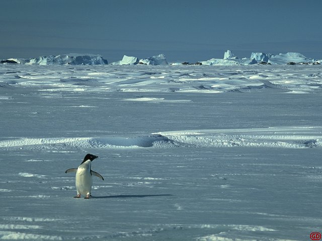
Most penguins spend the majority of their life at sea and return to land to reproduce. Getting to and from their reproductive areas (called rookeries) on land can be quite a walk but when there is snow to traverse, they often sled downhill to make quick descents.

On land, penguins walk (often in straight lines) to and from the ocean between their nesting colonies and their feeding grounds in the ocean (left). These trips can be only a few hundred yards over rocky beaches (like the picture above left) or they can be miles inland, often over snow and ice. Penguins tend to follow the same paths to and from the ocean to feed and bathe. When there is snow in their path they leave footprints (right).Most penguin species spend the year at sea without staying with their mate, returning each summer to their original breeding grounds and often to their original mate. The numbers of Antarctic penguins has been increasing over the years, a result perhaps of the decrease (from whaling) in the number of baleen whales visiting Antarctica. Without so many baleen whales (krill eaters) visiting Antarctica the krill population has increased and there is more food than ever before for the antarctic penguins.


There are 17 species of penguins on Earth, six of which can be found in Antarctica - three brush-tailed, (genus Pygoscelis) - the Adelie, chinstrap, and gentoo; one crested (genus Eudyptes) - the macaroni; and two species of Aptenodytes - the king and emperor.


Nest building - All but king and emperor penguins build a nest, though they are usually only a simple pile of stones that are continually stolen and swapped between the members of a colony. The nests are slightly higher than the surrounding land so that if the temperature rises and the snow melts, the nest is not flooded. Emperor and King penguins keep the egg and then the young chick on their feet covered by a brood pouch until they are large enough to regulate their own temperature.


Breeding Colonies - penguin colonies are very loud, raucous, busy and smelly affairs. The call of all penguins is as musical and gentle as a braying jackass and the whole colony is usually awash with penguin guano (posh word for bird poop). When I was in Antarctica one thing I did was help with long-term surveys which entailed walking through the colony (terribly frowned upon these days). Each nest is just over two pecking distances apart so the penguins can't reach each other. Of course walking through the middle meant that you were in range of everyone. I used to worry a lot about falling over in a penguin colony, covered from head to toe in guano and pecked mercilessly.


Reproduction: Colonies may be of just a handful of breeding pairs or up to half a million birds and more. Many species lay two eggs, though it is rare that two chicks are raised, if food is short it will be fed to the biggest and strongest only. Male and female parents share egg and chick duty. Chicks are fed regurgitated fish and krill (yum!). The chicks leave the nest (or parents feet) when they are large enough to keep their own temperature constant, they form crèches to give each other mutual support and protection from marauding skuas and also to protect against the cold and wind.


Saturday 28 May 2011

Golden Temple in amritsar


The Harmandir Sahib (or Hari Mandir) in Amritsar, Punjab, is the holiest shrine in Sikhism. Previously (and still more commonly) known as the Golden Temple, it was officially renamed Harmandir Sahib in March 2005. The temple (or gurdwara) is a major pilgrimage destination for Sikhs from all over the world, as well as an increasingly popular tourist attraction.

Unlike many historical sacred sites, the Golden Temple of Amritsar is still fully alive with religious fervor and sacredness, and visitors are welcomed to join in the experience. Although the building itself has great historical and architectural interest, it is the Golden Temple's great spiritual meaning for Sikh believers (and others) that is most memorable to visitors. In a country that is exceptionally rich with vibrant devotion, Frommer's rates the Golden Temple "the most tangibly spiritual place in the country."


History

Construction of the Golden Temple began in 1574 on land donated by the Mughal emperor Akbar. The building project was overseen by the fourth and fifth Sikh Gurus. The temple was completed in 1601, but restoration and embellishment continued over the years. The temple had to be substantially rebuilt after it was sacked in the 1760s.

In the early 19th century, 100 kg of gold were applied to the inverted lotus-shaped dome and decorative marble was added. All this gold and marble work took place under the patronage of Maharaja Ranjit Singh. The legendary warrior king was a major donor of money and materials for the shrine and is remembered with much affection by the Sikh community and Punjabi people.

In June 1984, Indian Prime Minister Indira Gandhi ordered an attack on armed Sikh militants holed up in the Golden Temple. Over 500 people were killed in the ensuing firefight, and Sikhs around the world were outraged at the desecration of their holiest site. Four months after the attack, Gandhi was assassinated by her two Sikh bodyguards, leading to a massacre followed in which thousands of Sikhs lost their lives.

The Sikh community refused to allow the central government to repair the damage to the temple, instead undertaking the work themselves. Although most of the damaged been repaired, the incident has not been forgotten. Many people in Amritsar are still anxious to explain the Sikh side of the story to visitors.

What to See

Despite its great sacred status, the Golden Temple is open to visitors, like all Sikh temples. The only restrictions are that visitors must not drink alcohol, eat meat or smoke in the shrine. And unlike many other Indian temples, visitors to the Harmandir Sahib are made to feel truly welcome and not pressured to buy anything. The information office left of the main gate gives helpful advice and information, as well as booklets on Sikhism.

Most visitors to the Golden Temple, whether Sikh or not, are humbled by what is quite simply the most tangibly spiritual place in the country. Arrive with a few good hours set aside and get lost in its magical beauty. Visitors must leave their shoes at the facility near the entrance, cover their head (bandanas are provided, or you can buy a souvenir bandana from a vendor), and wash their feet by wading through the shallow pool before entering.

The most famous and sacred part of the Golden Temple complex is the Hari Mandir (Divine Temple) or Darbar Sahib (Court of the Lord), which is the beautiful golden structure at the center of a large body of water. The gold-plated building features copper cupolas and white marble walls encrusted with precious stones arranged in decorative Islamic-style floral patterns. The structure is decorated inside and out with verses from the Granth Sahib (the Sikh holy book).

The water that surrounds the Hari Mandir is a sacred pool known as the Amrit Sarovar (Pool of Nectar). The temple is reached by following the Parikrama, which circumscribes the sacred pool in a clockwise direction. Connecting the pathway with the Hari Mandir is a marble causeway called the Guru's Bridge, which symbolizes the journey of the soul after death. The gateway to the bridge, the Darshani Deorhi, has magnificent silver doors.

The fascinating scene inside the Hari Mandir is televised throughout India for Sikh viewers. Amidst a crowd of fervent and solemn devotees, scriptures from the Holy Book are sung beneath a canopy studded with jewels. A chauri (whisk) is continually waved above the Book as lines of Sikhs pay their respects by touching their foreheads to the temple floor and walls, continuing in a clockwise direction at a relaxed pace.

Another major highlight of the Golden Temple complex is the Guru-ka-Langar, a dining hall where around 35,000 people a day are fed for free by temple volunteers. Everyone is invited to join this communal breaking of bread. All participants sit on the floor, regardless of caste, status, wealth or creed, powerfully symbolizing the central Sikh doctrine of the equality of all people.

Guest quarters are also available for international Sikh visitors (for a nominal fee), and at least 400 simple rooms are provided (free of charge) to Sikh pilgrims.

In the Central Sikh Museum at the main entrance, galleries display images and remembrances of Sikh gurus, warriors, and saints; it includes some graphic portraits of the torture and execution of gurus.

Festivals and Events

Every night, the Granth Sahib is carried in procession along this bridge to its "bed" in the Akal Takht, the seat of the Sikh parliament (built 1609). Called the Palki Sahib, this nightly ceremony provides a chance for all male pilgrims and visitors to actively participate in the veneration of the Holy Book. Lines form in front of and behind the heavy palanquin and each man shoulders the burden for a few seconds before passing it along, forming a human conveyer belt that allows everyone to participate and everyone to rest. The ceremony usually takes place at 11pm in summer at 9:30pm in winter.

Kalighat


Kalighat is located in the city of Calcutta on the banks of the river Hooghly (Bhagirathi). The name Calcutta is said to have been derived from the word Kalighat.
kaali.jpg (85615 bytes)
Kaali is regarded as one of the principal deities of Bengal. There are other temples to Kaali - Sahasrabhuja Kaali, Sarvamangala, Tarasundari and Simhavaahini. Kaali is regarded as the destroyer or liberator and is depicted in a fearful form. Despite the terrifying form, she is considered to deliver bliss to worshippers. The Kalighat temple attracts numerous devotees throughout the year.

Kalighat is regarded as one of the 52 Shakti Peethams of India, where the various parts of Sati's body are said to have fallen, in the course of Shiva's Rudra Tandava. Kalighat represents the site where the toes of the right foot of Shakti or Sati fell. (see Daksha Yagna).

The Temple: The Kalighat temple in its present form iis only about 200 years old, although it has been referred to in Mansar Bhasan composed in the 15th century, and in Kavi Kankan Chandi of the 17th century.

Legend has it that a devotee discovered a luminant ray of light coming from the Bhagirathi river bed, and upon investigating its source came upon a piece of stone carved in the form of a human toe. He also found a Syayambhu Lingam of Nakuleshwar Bhairav nearby, and started worshipping Kaali in the midst of a thick jungle. This shrine grew to its present form over a period of time, thanks in particular to the Sabarna Roy Chowdhury family of Bengal.

This family is also said to have built the Chitreswari Kaali temple at Chitpur. It is believed that there was a pathway through the jungle between Chitpur and Kalighat, and this pathway is said to have become the Chitpur road of Calcutta.

Kalighat is also associated with the worship offered to Kaali by a Dasanami Monk by name Chowranga Giri, and the Chowringee area of Calcutta is said to have been named after him.

The Dakshineswar Kaali temple across from the river, near Belur Math, bears an image of Kaali worshipped by the spiritual leader Ramakrishna Paramahamsa, guru of Swami Vivekananda.

Kerala is a paradise


Kerala is a green strip of land, in the South West corner of Indian peninsula. Kerala is one among the longest-lived, healthiest, most gender-equitable, and most literate regions outside of the developed countries. "Though Kerala is mostly a land of paddy-covered plains, statistically Kerala stands out as the Mount Everest of social development; there's truly no place like it." says noted environmentalist Bill McKibben.
Kerala, known as the 'God's Own Country' is one of the most beautiful places in the world. Known for its beautiful extensive backwaters and beautiful beaches, Kerala is one of the major tourist attractions in India. Nicknamed as one of the "10 paradises of the world" by the National Geographic traveller, Kerala is famous especially for its ecotourism initiatives. Its unique culture and traditions, coupled with its varied demography, has made it one of the most popular tourist destinations in India. Kerala is nominated as one among the three finalists at the World Travel and Tourism Council's ‘Tourism for Tomorrow’ awards in the destination category.
Kerala offers a wide range of Tourism possibilities. Nature tourism, Backwater Tourism, Monsoon Tourism, Eco Tourism Cultural Tourism and Health Tourism are the important forms of Tourism offered by Kerala. Herer we list the most imporant tourist spots of Kerala. These are the gem among all the tourist spots in Kerala. If you are planning to visit Kerala, make sure you don't miss any of these.

Thailand beaches


The beaches of Thailand are the main reason many people come. While they all pretty much have white sand, calm seas and warm water, there are also lots of variations to choose from. Which one is the best? Well, it's all really a matter of taste. As beaches go, the north end of Chaweng Beach on Samui is one of our all time favorites. However, Samui is probably one of the most expensive destinations in Thailand, with very little to see and do away from the beach.
Phuket is one of Thailand's most developed beach resorts. That means there's a wide range of accommodations in all price categories, as well as a few more distractions once you leave the beach. But, that high level of "could-be-anywhere" development is because there are a lot of tourists to serve. Phuket is not the place to "get away from it all."

In the end, our personal favorite is the little known provincial town of Songkhla in the deep south. The beach is rather "wild", with the occasional rock outcrop, but it's natural wind-swept beauty is precisely why it appeals. Few tourists frequent this part of Thailand, yet there are many interesting sights around town as well as further afield.
Of course, there's no point in going to the beach if it's going to rain. All of Thailand is subject to the seasonal monsoon cycle, but it peaks in different destinations at different times. See our Phuket vs Samui weather chart for a simple comparison of the seasonal rainfall averages for two of the most popular destinations.

Places to visit in nepal


Are you ready for some high altitude adventure with in a soul-warming environment? Then pack your bags and experience some of the most majestic peaks, most exhilarating torrents and wonderful people Nepal has to offer. Here are some places you may want to visit when go.

1.) Katmandu

Find your inner peace in the streets of Nepal's capital and cultural center. You can walk on the streets of this once inaccessible city and experience the culture, the people, the history, and the faith Nepal had embraced, imbibed, and relived for centuries. Katmandu is also one of the Nepal's starting points in activities like trekking, rafting and other sports.

2.) Royal Chitwan National Park

If you want to experience some jungle adventure with the elephants and ravaging rapids, you may want to stop by Nepal's Royal Chitwan Park. Covering some 932 sq kilometers, this national park serves as a home for 450 species of birds, 45 species of reptiles and amphibians, and 43 species of mammals. One can also enjoy guided jungle walks, terai culture, wild life breeding project, and safari drives inside 4WD cars.

3.) Nagarkot

Located 32 kilometers east of Katmandu, Nagarkot is a great place to visit if you want to see how beautiful and majestic the Himalayan Mountain range can be. A lookout tower in Nagarkot, for one, enables visitor to have a 360-degree scenic view of the Katmandu valley and Himalayan Mountain peaks. Drive up the city, book for a hotel, wake up early, and experience a different kind of sunrise with cool winds blowing every word away.

4.) Pokhara

Located some 200 kilometers west of Kathmandu, this enchanting city is the rally point for trekking and rafting destination. Pokhara offers perfect scenery and gripping natural beauty not only for those who looks for fun but also for those seeking solace. Be it the preview of the Himalayan Mountain range, a row in Phewa Lake, a trek beside Seti Gandaki River and Devi's Fall, or a peek to the Mahendra Cave, a trip to Pokhara is a experience worth the journey.

5.) Pashupatinath Temple

Four kilometers east of Katmandu lies a temple of immeasurable sacredness for Hindu people - the Pashupatinath. Hindu believes that dying and being cremated in Pashupatinath and having one's ashes scattered in Bagmati River will give a Hindu salvation and release from the cycles of birth and rebirth. Have a peek of Hindus life, death and tradition by visiting this holy ground.

6.) Patan

Art lovers and enthusiasts should always put a stop in Patan in their Nepalese trip itinerary. Patan is the oldest city in the Ksthmandu valley and is the home for Nepalese architecture, arts, traditions, and crafts drawing mainly from religious customs. Walk around the city and feel as if you're walking inside an open museum.

7.) Wildlife Reserve of Koshi Tappu

Sprawling some 175 km2 near the River of Sapta-Koshi in Eastern Nepal, Koshi Tappu Wildlife Reserve is the best place to watch native and migratory birds in action. Thousands of birds converge in this area, especially during the months of January, February and March. The trip which normally includes jungle walks, jeep drives, and boat rides, coupled with treks to Bhutan and Sikkim or rafting trip in Sunkosi will make any Nepalese trip an unforgettable experience.

8.) Lumbini

Lumbini is the perfect place to go to if you are into cultural, archaeological and religious treasures. With the number of stupa, meditation grounds temples, courtyards and more, a walk in Lumbini is a walk with Buddha. Enter the birthplace of one of the greatest man of world religions - Siddharta Gautama, founder of Buddhism - and be captivated by its serene environment and meditate and reflect with its outmost tranquility and peaceful atmosphere.

9.) Bhaktapur

Bhaktapur is an ancient town east of Katmandu in the Katmandu Valley. Experience Nepalese life as it happens in this city by enjoying the scenery in Bhaktapur Durbar Square and Potter's square. Make your trip complete with a taste of Khopa Dhau, Bhaktapur's home-made curd.

10.) Royal Bardia National Park

Located in Western Terai, Royal Bardia National Park is the largest park in the region with 968 km2. It serves as a sanctuary for tigers, small and large mammals, deer, reptiles, birds, and a herd of the last known elephants in captivity. Enjoy wildlife as it happens along with short rafting in Karnali and Bheri as well as trekking to Dolpo and Rara lake.

Melbourne city

It is situated at the head of Port Phillip Bay and the mouth of the Yarra River. The area was discovered by Europeans in 1802 and incorporated into the colony of New South Wales. The first permanent settlement was founded in 1835 by settlers from Tasmania, and in 1837 it was named for the British prime minister, Lord Melbourne. The city was made the capital of Victoria in 1851, and it grew rapidly with the gold rush of the early 1850s. It served as the first capital of the Australian commonwealth (1901–27), until Canberra became the new capital. Second in size to Sydney, it is an industrial, commercial, and financial centre and the seat of several universities, including the University of Melbourne.

The landscape
THE CITY SITE
Metropolitan Melbourne is situated at the northern end of Port Phillip Bay, 30 nautical miles (55 km) from the bay’s narrow entrance. Most of the flat terrain is less than 390 feet (120 metres) above sea level. The expansion of Melbourne from its origins at the mouth of the Yarra River to its present shape displays a strong correlation with the geology and drainage of the land. West of the original city site, basalt flows during the Cenozoic Era (i.e., the last 65 million years) filled the existing valleys and left flat, uniform plains. The eastern region, however, consists of undulating and dissected beds of sandstones, shales, and conglomerates laid down in the Silurian and Devonian periods (about 445 to 360 million years ago). The thicker soils of the eastern region, together with its higher annual rainfall, supported a much denser cover of trees than on the basalt plains. Not surprisingly, the development of Melbourne has been mainly eastward into the broad reaches of land between Darebin Creek, the Plenty and Yarra rivers, and Koonung and Gardiners creeks. In a strikingly asymmetrical fashion, Melbourne’s urban development presently lines the entire eastern shore of Port Phillip Bay, from the mouth of the Yarra River to Point Nepean, 60 miles (97 km) distant, while corresponding development on the west coast of the bay extends for only 10 miles (16 km).

climate

Melbourne’s weather results from the eastward flow of high-pressure cells separated by low-pressure troughs. These patterns follow a course that passes south of the continent in summer and over northern Victoria in winter. The annual rainfall of 26 inches (660 mm) is fairly evenly distributed throughout the year, with October usually the wettest month and January the driest. Temperatures are moderate, only rarely falling below freezing; average daily maximum temperatures vary from 55 °F (13 °C) in July to 79 °F (26 °C) in January. Winds associated with the eastward passage of weather systems ensure that Melbourne is spared the serious of some other large cities.
THE CITY LAYOUT
The area of original settlement in Melbourne, which today forms its financial, legal, administrative, and ecclesiastical heart, was laid out in a rectangular pattern that has not changed. The area has a frontage along the Yarra River. Within this core are the major suburban and interstate railway stations, Victoria’s Houses of Parliament, the Anglican and Roman Catholic cathedrals, arts and entertainment venues, museums, the Law Courts, the State Library, and many financial institutions, including the Melbourne Stock Exchange and the headquarters of major banks. Central to this area are two major destinations, Bourke and Swanston streets, which have been transformed into pedestrian malls, closed to automobile traffic. Most of the city’s buildings are modern, but the Town Hall, the Law Courts, and the Exhibition Building provide excellent examples of 19th-century official architecture. The city is divided into 14 precincts, sectors identified by ethnic concentration, commercial clusters, or attractions.
The people
PATTERNS OF IMMIGRATION
The first official census of Melbourne, in 1836, numbered 177 persons, of whom 35 were females. In the 1850s the gold rush in nearby areas of Victoria sparked the city’s first major period of immigration. Newcomers came principally from other Australian colonies and Britain. By the 1920s Melbourne had become the home of more than half the residents of Victoria, and toward the end of World War II it reached a population of 1,000,000. This trend continued throughout the 20th century. By 2000 the Melbourne metropolitan area comprised nearly three-fourths of Victoria’s population.
MOVE TO THE SUBURBS
In the 1940s about 90 percent of Melbourne’s residents lived within 10 miles (16 km) of the central business district. This proportion fell to less than 50 percent by the 1980s as the outer suburban areas grew correspondingly. By 1966 the population of the Melbourne area had exceeded two million, and the city limits were rapidly being pushed eastward. The migrants from southern Europe were at first concentrated in the older industrial suburbs, where they found lower rents and nearby job opportunities. In those areas support was available from earlier immigrants and the associations they had established. As these people prospered, they embraced the Australian dream of owning a home on a quarter-acre plot and began to move to the outer suburbs. By the mid-1990s the area’s population had surpassed the three million mark. By the end of the 20th century, however, the trend of moving to the suburbs had begun to reverse itself. The central city became increasingly residential as many aging buildings were rehabilitated and repurposed as housing. Melbourne’s suburbs, on the whole, represent a fairly even mixture of and occupations, although some western sections can be typified as working-class districts.
The economy
INDUSTRY AND TRADE
That Melbourne dominates the economic life of Victoria is not surprising—the city contains the bulk of the state’s population. It is Victoria’s financial centre and seat of government and is at the hub of the communications network linking the state to the rest of Australia and the world.
The city’s original core offers the most employment, but employment is growing at a faster rate in the outer suburbs. The central city mainly holds service activities such as banking, insurance, retailing, entertainment, public accommodation, and railway transportation. Surrounding this core is an incomplete ring of inner industrial suburbs, where the first clothing and metal factories were established in the 19th century. In the outer suburbs, particularly to the east, small manufacturing areas began to develop after World War II, when these suburbs could offer large areas of inexpensive land, few problems of traffic congestion, and an increasing population.
TRANSPORTATION
Melbourne is well served by an integrated public transportation system of electric trains, buses, and tramcars, the latter a signature sight in the city. A network of national highways links Melbourne with adjoining states, and a system of freeways was greatly upgraded in the 1990s, including the creation of the Western Ring Road as a bypass route. The City Link project joined three major freeways with a bridge, tunnels, highway extensions, and interchanges to facilitate traffic movement. An underground rail loop serves the central business district. Melbourne’s international and domestic airport is located at Tullamarine, 14 miles (23 km) northwest of the city’s centre.
Administration and social conditions
GOVERNMENT
The Victoria state government has the ultimate responsibility for Melbourne’s major planning decisions and for providing its principal health, educational, and transport services. Local government in the Melbourne Statistical Division is provided by more than 30 entities. Councillors, led by a lord mayor, are elected under a system of compulsory voting conducted by mail. Councillors receive a stipend and represent the city at large. The councils pass local ordinances and control a number of services connected with building regulations, community welfare, garbage collection, and vehicle parking. Revenue for these purposes is raised by property taxes (rates).
HEALTH AND EDUCATION

Since the system of free public hospitals was started in 1846, it has grown to encompass numerous special facilities, which deal with either particular ailments or categories of patients, as well as general hospitals. There are, in addition, many private hospitals.
The University of Melbourne, one of the oldest in Australia, was established in 1853 (though the first students were admitted in 1855); Monash and La Trobe universities were established in the 1960s, and Deakin University, established in 1974, maintains three campuses. Melbourne also has colleges of advanced education that offer degrees or diplomas in a variety of technical and academic subjects.
Cultural life
ARTS
Melbourne’s already rich cultural life was greatly enhanced during the period between 1968 and 1984, when the Victorian Arts Centre was created on the south bank of the Yarra River close to the city’s centre. It encompasses the National Gallery of Victoria, the Melbourne Concert Hall, and several theatres, among other facilities for the arts.
The National Gallery of Victoria was originally opened in 1861 and moved to its present site in the arts centre in 1968. It houses several outstanding collections, including, most notably, Australian art ranging from the colonial period to modern times; European art, with 18th-century works particularly well represented; and .
RECREATION

Automobile license plates in Victoria carry the identification “Victoria—Garden State.” Melbourne is worthy as the capital of a garden state, with more than one-fourth of its inner-city area consisting of public parks and reserves. These spaces were set aside in the mid-19th century, at a time when many civic leaders in other cities were concerned with commercial development rather than with the quality of life. Extensive tracts have also been allotted as parklands in the newer outer suburbs.
The most famous park in Melbourne is the Royal Botanic Gardens (RBG). This area of 89 acres (36 hectares) was established in 1846 and today contains lakes, lawns, and thousands of named trees and shrubs. The associated National Herbarium of Victoria, which houses a collection of 1,200,000 pressed plant specimens, is internationally recognized and used by scholars. The RBG also maintains a separate 200-acre (80-hectare) facility at Cranbourne, about 30 miles (48 km) southeast of central Melbourne.
History

Early settlement
Port Phillip Bay was discovered by Europeans in 1802, when Lieutenant John Murray and Captain Matthew Flinders visited the bay within a few months of each other. This area was then part of the colony of New South Wales, and the colony’s governor, Philip Gidley King, instructed the surveyor-general, Charles Grimes, to examine the shores of the bay with a view to identifying sites for future settlement. In 1803 Grimes and his party discovered the Yarra River and traveled along its lower course. Unlike some members of the party, Grimes was not enthusiastic about the Yarra River as a potential settlement. Later in the same year Captain arrived with a contingent of soldiers and convicts and settled near Sorrento, just inside the entrance to the bay on the east coast. Within a few months, however, he decided that the location was unsuitable and moved his group to Tasmania.
Growth of the city
Melbourne capitalized on its central position within Victoria and its port facilities to capture most of the region’s trade. Between 1856 and 1873, railways were built to Geelong, Ballarat, Bendigo, Echuca, and Wodonga, and in 1883 a link with the New South Wales rail system was established at Albury. In 1877 the Melbourne Harbour Trust was created, and the Coode Canal was cut in the soft alluvial sediments of the lower Yarra River to provide a more direct course free from silting problems.
During the 1870s manufacturing flourished under the protection of a high tariff, and progress in most spheres continued until 1889, when a financial crisis and the collapse of many firms lowered public confidence. The following decade witnessed a severe economic depression that began with a maritime strike and the failure of a number of banks and was sealed by seven years of drought from 1895 to 1902. In the decade before 1891 the population of Melbourne had increased by 200,000; in the following decade it rose by only 6,000.
In the early years of the 20th century, confidence gradually revived. Australia became a commonwealth, and Melbourne served as its federal capital until 1927, when Canberra was established. World Wars I and II encouraged the growth of manufacturing, and after 1945 European immigrants began to arrive in significant numbers.
After 1971 Melbourne’s rate of growth slackened as immigration declined, and economic conditions worsened through the 1970s and early ’80s. Nevertheless, during this period of slower population growth a number of major changes took place. The appearance of the inner city was transformed by the replacement of old buildings with multistory office structures and hotels. The system of arterial roads was improved dramatically. Several important suburban economic areas emerged, reducing the retail and industrial importance of the city’s centre. And the cultural life of the city was immeasurably enlivened by the completion of the Victorian Arts Centre. The revitalization of central Melbourne continued after 1990 as the residential population grew and the massive Docklands development project began to transform the long-neglected waterfront area into a spectacular urban showplace.


Durban

Durban is a sophisticated cosmopolitan city of over three million people - a city where east meets west - a city beneath which beats the pulse of Africa - city known as the home of Africa's best managed, busiest port.

Durban beach on GlobalGrasshopper.comDurban is an exciting city in which to play, shop, experience the nightlife and to relax. It's a city in which business and debate issues, which have far-reaching effects, not only on Africa but way beyond its borders, are discussed.


The world-class International Convention Centre Durban has hosted an historic line-up of events including conferences of a global scale.

Leisure facilities abound in Durban. Visit uShaka Marine World, Wilson's Wharf on the Victoria Embankment and the nearby BAT centre. Enjoy fine and traditional dining, entertainment and shopping in scenic surroundings. Shop till you drop in modern shopping malls. Grey Street and the Warwick Triangle boast vibrant locals shops and markets. Beachfront stalls sell traditional arts and crafts. Enjoy the excellent entertainment on offer at the city's theatres and clubs or take a township tour.

If it's peace and sheer beauty you are after, make for Durban's nature sanctuaries or parks. The Botanical Gardens are of particular interest - ask about their 'Music by the Lake' evenings - wonderful music played by KZN's Philharmonic Orchestra in wonder surrounds.

Sail, swim, run, and play tennis or alternatively stroll along or relax on the sun-drenched beaches watching the world go by. Durban the Playground of the Zulu Kingdom.